
Antycip Partners With LuxCarta Geospatial
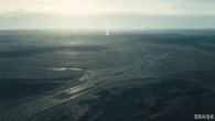
⊲ ST Engineering Antycip ⊳ ST Engineering Antycip has partnered with geospatial specialist LuxCarta to give French defence organisations faster access to AI driven, high resolution terrain and object data for situational assessment and operational planning. Antycip will provide local access and licensing for LuxCarta’s tools, with both companies also examining opportunities in Italy and Spain. LuxCarta’s BrightEarth platform automates extraction of geographic objects, cutting the time needed to produce usable mapping products, including for crisis response and civil military support. The partners also see scope for AI generated terrain data in simulation, digital twin and immersive training environments.
⊲ Image – LuxCarta ⊳
www.simulation.news